Monday, January 30, 2006

Introduction

Firstly, I should point out that none of the dates here (apart from this post) are the dates that I actually typed in the text. Rather they refer to when I originally wrote the notes down in a notebook. I fiddled around for ages with my own website, but couldn't quite find the time to finish it, before I realised that I could use a blog to add the text at least. The images could then be added when I've sorted them out.

The other impetus for this is that R. wants to go back to the ice for another trip. We'll see!
IMB

Monday 28th February 2005; 1st day at sea

Well, strictly speaking we were in the Beagle Channel, which isn’t exactly open sea, until nearly midnight, having left Ushuaia at 7 p.m.

Leaving Ushuaia

The evening included a talk from the expedition leader doing the induction, a lifeboat drill, which involved putting on your lifejacket – kept in the cabin – and going to the port or starboard side of the ship so that someone could check that you had put the lifejacket on correctly, and the captain’s welcome dinner. This was a four-course meal; soup, salad and main course and pudding, and this was typical of the meals on board, lunch included. There was really too much to eat, and by about half way through the trip I was skipping soup and only taking a small plate of salad. We didn’t see much of the Beagle Channel, being in the dining room until it was nearly dark, so I missed a sight of the Harberton Estancia, established by one of the more sensible missionaries who compiled a dictionary of the local Indian language. Puerto Williams (in Chile) could be seen as a collection of lights on the south side of the Channel. It’s the southernmost town in the world, thought it was really a naval base until a few years ago.

Tuesday 1st March; 2nd day at sea

Or the first full day at sea, and it was rather choppy for me at least. The Stugeron I had taken for seasickness wasn’t having much effect and whilst the Drake Passage was quite quiet as far as sailors would be concerned, it was making me feel rather queasy. Not that much was happening; the ship was sailing on a more or less straight course across the sea heading for the South Shetland Islands. I skipped lunch, on the grounds of illness, and went to the doctor to see if I could get anything more effective. What I got was Marzine, which whilst it’s rather old-fashioned, did seem to have more of an effect, and I did manage to eat some dinner; as I was to find out, I had no problem keeping food down, rather it was staying upright long enough to eat something, especially when you couldn’t help yourself whenever you wanted.

I skipped the planned lectures for the day as well, but still managed to hear the good news that as the wind was behind us it had given us a bit of a push and we were going to get to the first islands early. We were early enough, in fact, to get an extra landing on Aitcho Island.

Wednesday 2nd March; 3rd day at sea

Woke up this morning (this is starting to sound like a blues song) and felt a little better. Breakfast is a lot easier than other meals as you simply get things for yourself, so there’s less hanging around. I still skipped the morning lecture and decided to stay on the bridge. This ship has an open bridge policy (as do most of the Antarctic tour ships) but for us that means you can go anywhere you like on the bridge as long as you don’t get in the way. Most ships like ours like the passengers to stay on the port side of the bridge out of harms way, and the American are apparently keen, in a fit of post-9/11 security paranoia, of making bridges out of bounds to everyone except the normal crew. Our ship by comparison tended to have a normal complement of one officer on watch, the occasional presence of the captain, at least 3 expedition staff (the people taking care of the shore landings), plus up to a dozen passengers, some birders, but usually quite a few auxiliary captains, i.e. people who had a yacht back home and could look at a chart with some degree of confidence. The startling thing about the bridge was that no one appeared to be steering. I was almost expecting a Sub-Lieutenant Phillips type saying ‘left-hand down a bit, right hand up a bit’, but obviously the auto-pilot knows where the ship’s supposed to be going, and the GPS gives you an accurate reading of where you are, plus a little digital map of the location. Accurate up to a point that is. One of the auxiliary captains claimed to have seen a GPS show the position of a ship in a Chilean fjord as being on dry land!

Going to the bridge was a smart move. Hannah Lawson (one of the expedition staff) pointed out a fur seal to me, and then spotted a whale spout at which point the non-crew people on the bridge stated leaping about in a state of high excitement. I was being fairly nonchalant about it, lounging in one of the chairs on the bridge, until a whale surfaced a few hundred metres in front of the ship, whereupon I sort of squeaked a sort of ‘good grief (or words to that effect). As the lecture was on dolphins and whales it was suspended and loads of people rushed up to the bridge and forward deck to have a look, though all they really saw was a few fins, either of a Sei Whale or a Fin Whale – the experts will still disagreeing about it a fortnight later.

After the lecture resumed, and I was still hanging around on the bridge, the first iceberg was spotted, there being a competition to predict when the first the first iceberg was spotted. The berg was a smallish one, but still almost as large as the ship, and curiously the person who won the competition not only got the time exactly right, but also spotted the iceberg as well!

Iceberg in the Drake Passage

During lunch we passed through the Nelson Strait, between Robert Island and Nelson Island in the South Shetlands, and then turned west into the Bransfield Strait and sailed along the southern and then western coasts of Robert Island and anchored off Aitcho Island (confusingly in a small group of islands known as the Aitcho Islands). As we’d had the briefing on landing and zodiac procedures before lunch, we could then get ashore fairly quickly.

Zodiacs are inflatable rubber boats, powered by out-board engines, the inflatable part being in sections so that if there’s a puncture the boat won’t sink. Getting into them from the gangway down from the ship is pretty simple – just a question of co-ordination with the waves. Getting out is rather harder. The zodiac can get very close to shore, but you have to wade the last few yards, hence you have to have waterproof trousers and Wellington boots, and you have to get out by swinging one leg over the inflatable side and into the water followed by the other. Fine if you’re relatively young and fit, but we had people in their 80s amongst the passengers – they seemed to cope with some help from the expedition staff. Travelling in a zodiac is OK if the weather’s calm; otherwise it can become quite, “interesting”, and occasionally “interesting” in the sense of “get me out of here”. Our first trip in these zodiacs was quite easy however.

Aitcho Island was about 2km long and too small to be on any of the maps we had with us. It’s rare amongst Antarctic islands in that it’s rather green – caused by some moss beds. It was also our first introduction to Antarctic Fur Seals, which were widely hunted in the 19th and early 20th centuries, but have now become endemic in the Antarctic Peninsula and the sub-Antarctic islands. They’re very territorial, even outside the breeding season, can give you a nasty bite if you let them, and will tend to snarl and snap at you if they think you’re invading their bit of beach. The island also had some youngish male Elephant Seals, which are basically too big to be dangerous, unless you’re careless enough to lie down and let them roll on top of you.

The penguins, however, were easily the most impressive creatures. They ambled around – the odd one heading into the centre of the island for some reason – the ones on this island were apparently renowned for being very inquisitive. I think not having land predators is the major reason for their not regarding humans as being anything to worry about. On the way back to the zodiac, I took a photo of a penguin (a Gentoo, I think) feeding a chick from about 5 feet. We were supposed to be about 5 metres away, but the penguins tended to wander around and get quite close to you. Most of the penguins were Gentoos and Adélies but there was apparently a single King Penguin on the island. For me the former are easily the cuter penguins; Kings and Emperors, which are really the archetypal penguin, look a bit snooty – it’s almost as if the name has gone to their heads. Later in the trip, when we landed at Fortuna Bay on South Georgia, the zodiacs were met by what appeared to be a welcoming committee of King Penguins who almost looked as though they were going to ask us for our passports. Being on the island was like being on an alien planet. The landscape was strange, and we were protected against the environment, almost like wearing space suits.

By 10:30 in the evening we’d had dinner, part of the David Attenborough series “Life in the freezer” had been shown in the Observation Lounge, and we were off to Deception Island at 3 a.m. All in all, a good start to the trip.

Thursday 3rd March; 4th day at sea

At 7:20 a.m. we were cruising along the Bransfield Strait (named after an English naval officer who is now credited as the first person to sight the continent of Antarctica) heading for Deception Island. Livingston Island, off to starboard, was generally rocky with a snow covering, but there were glaciers coming down to the sea along its coast. The weather was OK and the sea was very calm, despite a lively breeze.

The ship was a Baltic Sea class ice breaker, which we found out later means it doesn’t need to get through more than about 2 metres of ice, which in turn means you can make some design changes compared to other icebreakers such as the ones the Russians use to keep the North-East Passage clear in the winter. It’s registered as 5,000 tons, which apparently is a measure of its capacity rather than its weight and is about 86 metres long and 21 metres wide. There are two main passenger decks, numbers 3 and 4, we were on the latter, with some extra cabins on 5 and 6. The Observation Lounge is on 5, towards the stern, occupying what was the helicopter deck before the ship was converted for cruises, and has large windows; there’s also a dining room, a bar, and a library, plus crew accommodation. The crew’s mostly Philippino, though the officers are either Polish or Czech, and the expedition staff are from various countries. The captain’s Norwegian, new to the ship, and he had to be re-educated when he came on board. He thought that people should have their shirts tucked in it seems, and the expedition staff tend to dress rather casually.

Deception Island itself is rather curious. It’s a caldera, essentially the crater of a volcano, and has a narrow entrance into the centre. The entrance was missed for quite a long time, hence the name, and no one realized that there was a safe anchorage available. Eventually of course its usefulness was spotted and a whaling station was established, at what’s now called Whaler’s Bay, in the internal harbour (called Port Foster). The island also proved useful for scientists and some bases have been established on the island; the British Base ‘B’ being set up in 1944 close to the whaling station. The volcano is still active and the abandoned whaling station and both the British and Chilean bases were destroyed in the late 1960s.

Deception Island

The ship went through Neptune’s Bellows, the entrance to Port Foster, not a simple manoeuvre – there’s a wreck of a British ship to the left of the entrance – and anchored in Whaler’s Bay. Once we were on shore, one party headed off on a long walk up to the hilly rim of the island, whilst we joined a group going up to Neptune’s Window, a gap in the hills around the island, from where you were supposed to be able to see the mainland of Antarctica. Despite the sun having come out, we couldn’t see that, but you did get a good view down into the ruins of the whaling station. After that we wandered back to the whaling station, along the beach, which was created by a volcanic mudslide, partly burying buildings, boats and a cemetery, to the oil tanks for the whaling station. There wasn’t much wildlife there other than the ubiquitous fur seals and a few giant petrels – the volcano acts as a deterrent it seems – but the industrial archaeology was impressive.

We were pottering about near Biscoe House, the ruins of the British Antarctic Survey (BAS) base, when the ship’s siren sounded; this was the signal to get back to the ship as soon as possible. From the shore you could see that the ship was anchored quite close to the beach, and the wind had been getting stronger though the morning. We found out later that the wind had got up to about 60 knots, which was the highest safe speed for operating the zodiacs, and it was obvious from the shore that if the ship had broken it’s moorings and had drifted onto the beach sideways we would have to be towed off.

Loading a Zodiac in Whaler's Bay

Given the wind, the second landing, at Telefon Bay, further into Port Foster, was cancelled and the ship headed out of Neptune’s Bellows and across the Bransfield Strait for the Antarctic Peninsula. By now the weather was wonderful; cold but bright and sunny, and as we got close to Astrolabe Island I could count about 40 icebergs from the ship. We could also see Antarctica itself by now; an apparently very high range of mountains, but as they were only about 5,000 feet high something must have been distorting the perspective.

After dinner I popped out to the stern of the ship to see if there was a decent sunset – nothing worth photographing – but as I peered around to the front of the ship I could see a large tabular iceberg ahead. As this looked interesting I went up to the bridge only to see loads of icebergs ahead of us – the real Antarctica. Neither the officer on watch nor the captain seemed concerned about it so I went to bed.

Friday 4th March; 5th day at sea

I woke up at 5:45 a.m. and peered around the blind to see where we were. We’d anchored at a place called Brown Bluff (so called because there was the obvious landmark was a brown bluff) and decided there was a possibility of some photographs. A few other people were up as well as a single Sheathbill. I took a few photos of the early morning light which seem to have come out quite well and then heard a distant crashing noise – not thunder but a large block of ice falling into the sea. We’d arrived during the night and anchored in a small bay with lots of icebergs, which dampened the sea so much that it hardly moved. With the almost total silence, the smallish icebergs and the early morning light it was a really beautiful place. We landed here for a while, the only time we stepped onto the mainland of Antarctica itself, and saw Gentoo and Adélie penguins, plus the usual fur seals, a Weddell Seal that more or less completely ignored us, and a Leopard Seal splashing just offshore.


Adélie penguins

Gentoo penguins

Weddell seal

This is apparently the only serious predator the penguins have and they weren’t keen to be in the water when it was around. It was here that we had the first casualty; one of the people in the same group as us had gone on a walk on a glacier, fallen, and broken her wrist. Fortunately there was a doctor on the ship (well, several if you counted the passengers) who strapped it up; there was no possibility of an x-ray until we got to South Georgia however.

After the landing there was time for a quick drink and then it was back into the zodiacs, eight of them this time, rather than the usual three, for a cruise down the Fridtjof Sound, which connects the Antarctic Straight at the top of the Peninsula with the Erebus and Terror Gulf (named after the Royal Navy’s two ice ships which James Ross took into the Ross Sea in 1841, and which were lost with Franklin’s expedition to find the North-West Passage in 1845). It seems being able to do this was quite rare but the wind speed was quite low and whilst there was a lot of ice around, it wouldn’t cause us any problems. The trip was a mix of drifting about and edging closer to any interesting wildlife, mostly seals or penguins, though some people saw a Minke Whale, or icebergs we could find, coupled with exhilarating bursts of 20 knots moving around the Sound. While we were out in the boats, the ship had moved off down the sound and anchored at the end of it. We got back on, and had lunch, whilst the ship headed off towards Devil Island.

This was to be our second landing of the day, on a small island a few hundred yards north of a larger one called Vega Island (named by a Swedish explorer Nils Otto Gustav Nordenskjöld – more about him later). Devil Island was quite small, and consisted of two hills, separated by a small neck of land. One party went up the larger of the two hills, but they were slightly outdone by the Captain who obviously fancied a trip ashore. He strode up the smaller of the two hills, and then went up the larger one as well. I don’t know what the view from the top was, but we went part of the way up the smaller hill and got a wonderful view over the iceberg dotted sea from there, looking over to the Prince Gustav Channel and the Trinity Peninsula on the mainland. On the way back to the ship, Hannah who was driving our zodiac, took us off on a “jolly”, as Malcolm, one of the passengers on the zodiac put it, to look at an iceberg, which due to age was heavily crevassed and was turning a nice shade of blue in places.

Old ice

The late afternoon and evening was very pleasant with a beautiful sunset behind Vega Island, and our first proper whale chase. Someone spotted a pod of Orcas (Killer Whales) off to starboard, and amidst the pandemonium on the bridge the officer on watch changed course and reduced the speed a little so we could get nearer to them. Eventually most of the passengers and also some of the hotel staff on the ship were on deck somewhere, either the outside observation level below the bridge, or the bridge wings, or the foredeck.

Sunset in the Erebus & Terror Gulf

Late that night we anchored off Snow Hill Island. About 11 p.m. I heard what sounded like the ship running over some wreckage, so I went up to the bridge to see what was happening. We’d been running over small lumps of ice throughout the evening and clearly we’d just crunched over more or large lumps. Everything seemed to be OK, and the captain was using the bridge searchlights to pick out where we were; all I could see was a brown wall, but I wasn’t sure whether it was rock or a large iceberg that whose colour was being distorted by something. According to the GPS/bridge computer we’d arrived so I went to bed.

Saturday 5th March; 6th day at sea

Another early morning and this morning’s landing was to be on Snow Hill Island, where Nordenskjöld’s hut had been preserved. He was the second person to stay over an Antarctic winter, in 1902-03, and the original intention was for his ship, the Antarctic, to pick him up the following summer. However, when the ship returned from the Falklands and South Georgia, it couldn’t get through the Antarctic Straight due to ice, so the captain, Carl Anton Larsen, a famous Norwegian whaler, dropped three men off at Hope Bay at the top of the Antarctic Peninsula to try to get through on foot to alert Nordenskjöld of the problem. They failed in this due to the open water between them and Snow Hill Island, so they settled in for the winter at Hope Bay, collecting seals and penguins for food and fuel and fossils to keep them selves busy. Nordenskjöld of course was unaware of this, so he was stuck for a second winter on Snow Hill Island. Larsen, in the ship, tried to sail round into the Weddell Sea, but the ship was crushed in the ice off Paulet Island. The following summer, the men at Hope Bay tried to reach Nordenskjöld again, and almost unbelievably met him whilst he was on a trip round James Ross Island. Nordenskjöld wasn’t apparently too sure who was approaching him and his colleague, Jonassen, was on the point of drawing his revolver under the impression that the three figures, black from head to foot and wearing wooden boxes with slits over their eyes, were Antarctic aboriginals. Larsen meanwhile had set off in an open boat to try and pick up the three men at Hope Bay, found a note they’d left, set off after them and reached Snow Hill only a few hours ahead of an Argentinian rescue mission had arrived in the area. The story is rather reminiscent of Shackleton’s 1914-1916 expedition, with the difference that only one man died (of a heart condition), whilst there were deaths on Shackleton’s expedition in the separate Ross Sea group, and isolated groups of men, when marooned, simply settled down, built themselves a hut, and not only collected food and fuel, but even kept themselves busy.

Nordenskjöld’s hut is still preserved, mostly by an Argentinian base on Seymour Island to the north, but rather oddly they’d decided to put some modern soap and deodorant in the hut. There were still piles of fossils outside the hut – Nordenskjöld’s main interest whilst he was stranded. The island itself consisted of loose shale, mostly a rather dreary brown colour, plus snow at the tops of the hills, and the usual glaciers running down to the sea. Despite this, and the fact that no animals breed here, it still remained quite impressive.

After the landing the ship turned to the West and we headed off down the Admiralty Sound, past Lockyer Island and around Snow Hill Island into the Weddell Sea. We didn’t apparently have charts for the area we were in and the bridge crew didn’t entirely trust the GPS and computer system which displayed maps of where you where. The sea was littered with ice of all shapes, sizes and ages. Not only tabular bergs, which were the remains of the Larsen B ice-shelf that spectacularly collapsed in 2001. We also saw the first sea ice; large flat floes with penguins and seals on them. At this point we reached the furthest south point in the trip, 64 ° 36' 34.33'' south. Two of the expedition staff also saw an Emperor penguin – the subject of another competition – and the captain decided that it was time to use the ship as an icebreaker. Curiously the 5 metre rule doesn’t seem to apply when you’ve got 12,000 horsepower and 1500 tons of metal under you, and we crashed into the ice floes, disturbing the seals calmly lying about, in an attempt to get closer to the penguins. This was a bit of a futile effort as one of them disappeared into the water, whilst the other calmly wandered off into the distance. The ice-breaking was quite good fun however; they don’t simply batter the ice from the front, but use a sort of rocking motion to go on top of a section of ice floe and then rock downwards to split it.

One of the things we learnt at the recap in the early evening was that probably only about 5,000 tourists have been as far as Snow Hill Island and of those, perhaps only a quarter have circumnavigated it – most tour ships go down the west side of the Peninsula. The downside of the day was that my glasses fell onto the deck of the ship as someone lent me a pair of binoculars to see the Emperor Penguins more clearly and now have a scratch in the right hand lens. I might be able to claim on insurance though.

Sunday 6th March; 7th day at sea

This was an entire day at sea as we headed for the South Orkney Islands through the Scotia Sea. The sea was still fairly calm, but there was a stiff headwind, which gave us a bit of a roll. There was still plenty of wildlife to be spotted; Cape Petrels (aka Pintados – a really beautiful bird), a Fulmar and a Light Mantled Sooty Albatross in the morning. In the afternoon there must have been more excitement on the bridge as a group of blue whales, possibly around eight or nine, were spotted and the ship went off its course to get a better look at them. A couple surfaced just beside and ahead of the ship, but getting photos of them was rather tricky as you didn’t know where they were going to be. Using binoculars was tricky for the same reason, so you generally got a better view of them with your own eyes, but without the detail. Blue whales, having been very heavily hunted in the past, are now quite rare, so seeing this many in one group isn’t at all common. Some estimates are that there are only about a thousand in the whole of the Antarctic.

There were still icebergs around us but these thinned out a little throughout the day. I don’t think I was affected by the sea very much, as I can remember the whales, and also the afternoon lecture on the history of whaling.

Monday 7th March; 8th day at sea

At about 4 a.m. this morning we sailed around Signy Island in the South Orkneys, home to a BAS base. This was a little confusing because I was expecting, given our planned course, not to be able to see land from our cabin window, but when I woke up there was an island off to starboard. Obviously we had changed course at some point.

After breakfast we anchored off Laurie Island, where there was an Argentinian base, Orcadas, and got into the zodiacs for a rough ride into the beach, straight into a force 7 wind with snow flurries in the air. We were met on the beach by the base commander, and Argentinian naval officer and the doctor. The base, which is the oldest continually operating station in the Antarctic, was originally set up as a meteorological station by a Scotsman, who miffed that the British Government didn’t want anything to do with in, handed it over to the Government of Argentina in 1904. It’s now operated by their Navy, both as a meteorological station and other work, notably seismological, but there’s a definite political element as well, as the Argentinian Government claims a large section of Antarctica. Not that we’re much better; I read recently that the money given to BAS from the Government went up by 3 or 4 times after the Falklands war, and we evicted an Argentinian base in the South Sandwich Islands in 1982 and apparently blew it up a few months later without bothering to clean up afterwards. Obviously the British military don’t do hoovering.

Anyway, because the South Orkneys are south of the 60th parallel, it counts as Antarctica, and all territorial claims have been frozen (sorry, couldn’t resist that) for a number of years. We were made really welcome, which was slightly surprising as the Polar Pioneer had been in the previous day, though we did trade some of our fresh eggs and vegetables for a case of Argentinian wine, which might have helped. They showed us around, let us into the small museum, which is the original hut, and is very well preserved – much better than Nordenskjöld’s hut on Snow Hill Island.

They also gave us the best cup of coffee we’d had since leaving Ushuaia. They do 14-month tours, so there’s a 2-month changeover period, which I wouldn’t really fancy much. The only way off the base is by ship and that’s only during the summer months, and whilst the British have a base a few miles away on Signy Island, they’re equally isolated. The base itself is situated on a small neck of land between two mountains, so the wind whistles though, and the beach to the north was crowded with lumps of ice.

The good news was that they seem to have good relations with the British. The officers’ mess had plaques from other ships that had visited, and I was pleased to see that HMS Endurance had been in at some point, and that the BAS base at Signy had given them a plaque. Even if they dated from before the war, then they hadn’t bothered to remove them. We added one as well; one of the expedition staff, Simon Cowell, thought that it was about time Bruce, the man who established the base, should get a mention, and had got a plaque made up in the UK, which he presented to the base commander.

The rest of the day was spent at sea en route for South Georgia. The snow that had been falling at Orcadas cleared, but the wind was still strong. On the subject of fresh vegetables, there was some speculation about how we were managing to get fresh lettuce after over a week at sea. The favourite theories were airdrops or teams of specially trained dolphins meeting up with the ship. Reality was more prosaic; apparently the ship has a very good fridge.

Tuesday 8th March; 9th day at sea

A whole day at sea, and in the middle of a gale. The sea therefore was very rough for much of the day, and I spent a lot of the day lying down. Breakfast was a bit brief, but I got through lunch quite well, and even made a couple of trips up to the Observation Lounge. The first was in the morning after I’d been told that there was some chocolate cake left over from the previous afternoon, and the second was in the afternoon, after the snack had been delivered at 4 p.m. The snack is either cake or biscuits, and in complete contrast to the coffee, or the tea that you get if you don’t make it yourself, is very good. It’s always home made, and on the last afternoon before we got back to Ushuaia, we had what can only be described as “chocolate lump cookies”.

By the afternoon the weather was getting worse, and the wind speed had got to 25-30 metres per second and was gusting to 35 on occasion; i.e. about force 12. I skipped dinner on the grounds that it looked like asking for trouble – I was right as I heard that the contents of an entire table ended up on the floor after a very heavy swell, and that about half the expedition staff and perhaps a third of the passengers were sick. The hot news today is that we’re going to give the Governor of the Falkland Islands a lift back from South Georgia – I’m expecting a man in a Colonial Governor’s full dress uniform, including the plumed, chicken-like, hat, but I suppose I’ll be disappointed.

During the evening the wind got worse and we were now in a full-scale hurricane. The ship was moving rather a lot, and sleeping involved coping with your centre of gravity moving forwards and backwards on the bed, plus from side to side, and up and down, frequently at the same time. My watch has got a barometer, and I spent a lot of the night checking the air pressure to see if it had increased from the 974mb it had got down to - it didn't. Meanwhile above our heads there was a lot of crashing noises, and a rolling sound that was rather reminiscent of an oil drum on the loose. Almost the worst aspect was the monotony; I knew we would get to South Georgia around 3 or 4 a.m., and that would mean we would be in much more sheltered water, but time seemed to drag interminably.

Wednesday 9th March; 10th day at sea

When I woke up the ship had anchored in Gold Harbour – our first landing point in South Georgia. I can’t remember getting into calmer water, so I must have been asleep, but once I’d got dressed I went up to the Observation Lounge, immediately above our cabin, expecting to see the whole place reduced to matchwood. Amazingly, it appeared to be completely intact, so I made myself a cup of tea and sat down to admire the scenery; very mountainous, with glaciers coming down the cliffs.

Word started to go around about the hurricane the previous night. The wind had gusted to a maximum of 84 knots (i.e. about 96 mph or 154 kph), the ship had had to tack to make any sort of headway, and the captain was reported as saying that he never wanted to go through anything like that again. One of the yachting wives said that she was mentally working out what she might need if the ship had had to be abandoned, but the thought of being in that weather in an 8 metre life boat with 60 other people, really doesn’t bear thinking about.

When we got ashore at Gold Harbour after breakfast I found out that one of my cameras, the SLR. wasn’t working properly. At first I thought the battery had failed, and I got a lift back to the ship in a zodiac to collect another. Replacing it made no difference, and I noticed that one of the indicator lights in the viewfinder still worked, which meant that the light meter or something connected to it wasn’t working. I eventually worked out that it was the shutter speed indicator that wasn’t working, but even so, I still had problems where there wasn’t very much light.

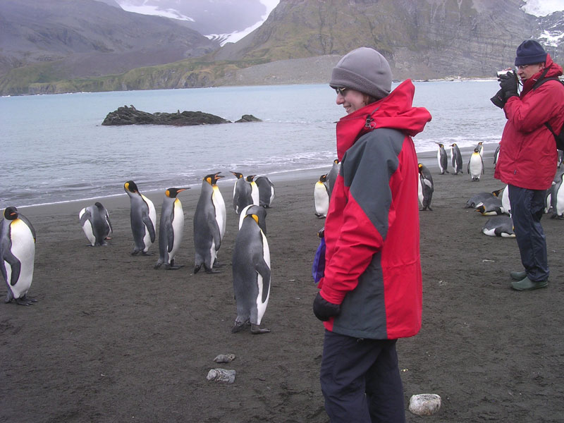
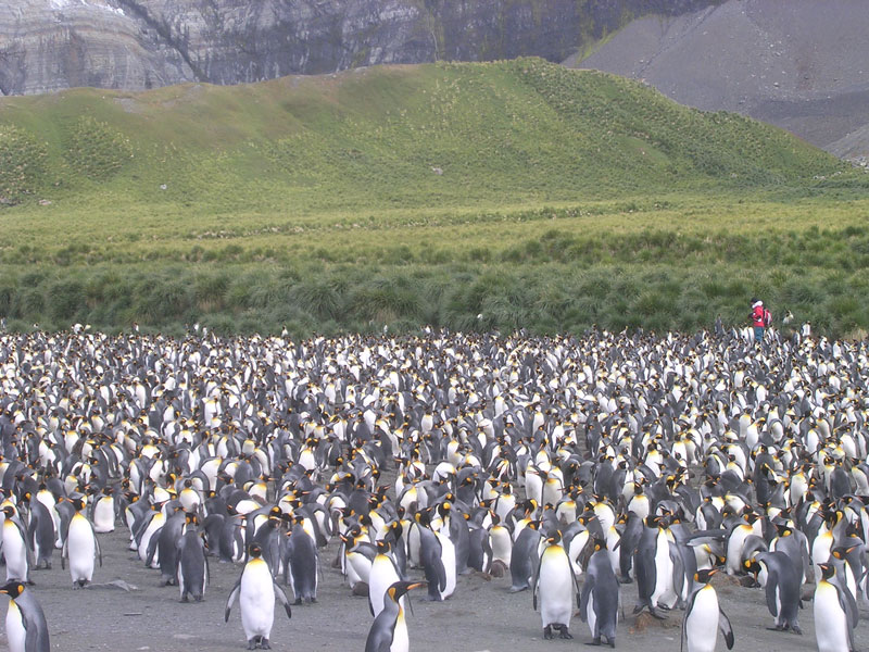
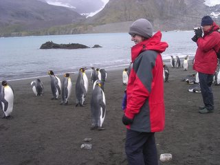
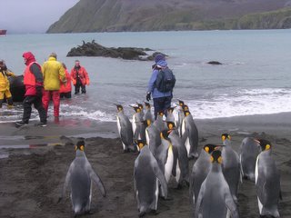
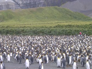
The highlight at Gold harbour was a colony of King Penguins, some of whom had formed a reception committee. Once we’d got past the usual mass of aggressive Fur Seals, there were quite a few Elephant Seals on the beach, some of whom were sizing up to each other, presumably in an attempt to keep their place in the hierarchy before the mating season, but this was the first time we had seen a large number of nesting penguins in one place. The rookery wasn’t as large as one we saw later in the trip, but compared to what we’d seen before it seemed huge. The was a small hollow, maybe 50-60 metres long that seemed to be full of King Penguins, though strangely, I can’t remember any sounds coming from it; they must have been making a noise though. The other thing I didn’t notice were any chicks; I think there must have been some, judging by a colony we saw elsewhere in South Georgia, but there were none here that I saw. I’ve just checked the expedition log and apparently there were 20,000 pairs here, but I think they can’t all have been where we were.


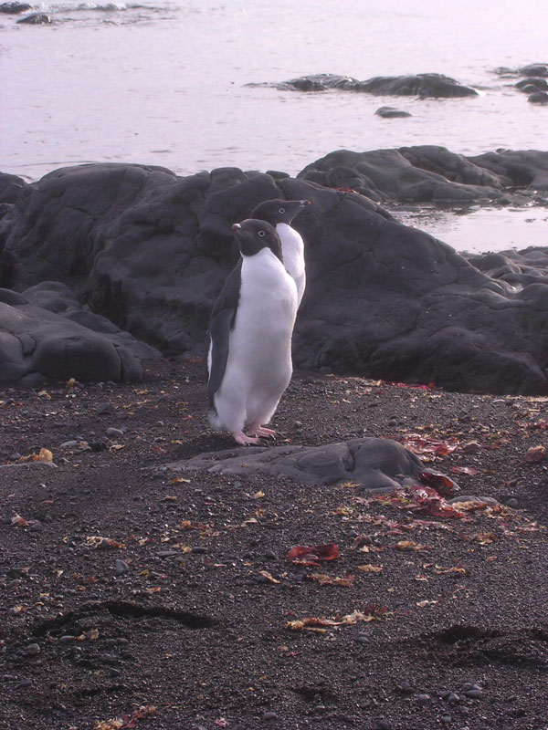
The reception committee at Gold harbourtext 2


text 3text 4


After the landing, the ship headed north to Grytviken, where we were due to make our second landing. By now the weather had worsened a little and it was overcast and snowing a little. We landed near the old whaling station’s cemetery where Ernest Shackleton is buried, and drank a toast over his grave, and were then free to go around the whaling station site, much of which is cordoned off whilst some tidying up is done, and visit the church and museum. The church has been restored and is used a few times a year; originally it came from Norway in kit form, the station being operated by a Norwegian company. The museum is really very good, with sections on Shackleton, the local wildlife, and the whaling operations. We could really have done with more time here; a whole day would have been better. As this was the first practical place to buy postcards and be able to send them off, we needed to get up to King Edward Point, the local BAS station, where the post office was.

The whaling station is in the process of being almost dismantled. There’s a lot of asbestos around, which the authorities are paranoid about, presumably because they get quite a few American tourists here, and as the buildings are disintegrating, there is a danger from loose sheets of metal. That apart, you did get an idea of how difficult life must have been here for the whalers. As well as a church, there was a rather rocky football pitch and there had been a cinema in the past. The station had been abandoned in the 1960s, but until then must have been a hive of industry.

It was at the Post Office that we first came across Howard Pearce, the Governor of the Falkland Islands and Commissioner for South Georgia and the South Sandwich Islands. We were in the queue to get our cards franked, when he popped his head round the door and asks if anyone could take him over to the ship (meaning the Polar Star). He didn’t get much joy; according to the person running the Post Office, there was no one available to take him over and she was too busy franking postcards (in addition to her day job of base manager). He obviously found someone else to get him across.

In many ways it must be a curious job, or rather jobs, as the Falklands Islands, and South Georgia and the South Sandwich Islands are separate dependencies of the UK. South Georgia in particular is rather odd; there’s no one to govern apart from some itinerant BAS personnel and the two people running the museum, who have been there for about 7 or 8 years, so the government’s activities are mostly to do with regulating fishing and looking after the natural and built environment.

In the evening we had the barbeque on the back deck of the ship; eating outside was optional though a few of the auxiliary captains put their coats and sat down at some tables. Along with the passengers and some of the ship’s officers the staff from King Edward Point were invited and the people running the museum (though they couldn’t come owing to a minor accident). As well as the Governor and his (Dutch) wife, we’re also taking a construction consultant who’s been working on the whaling station at Grytviken and a taxidermist from Essex who’s been working at the museums in Stanley and South Georgia and has been stringing his contract out for as long as possible. Rather odd having a barbeque in snow, but pleasant nonetheless.

Thursday 10th March; 11th day at sea

This morning I’d managed to get a minor stomach bug, which it’s just occurred to me, might have been caused by the chef’s penchant for doing steak rather rarely. At any rate I decided to skip the morning landing at Prion Island – where the highlight was nesting albatrosses. This was quite a complicated landing as the passengers were split into groups and kept together and I thought it might be a bit inconvenient if I needed to get back to the ship quickly. I stayed on the bridge most of the time, which as there was a radio link to the shore proved to be quite funny. Mostly it was inconsequential chatter between the 5 groups of passengers, but at one point Santiago, the Argentinian member of staff, radioed Hannah and I heard the following:

Santiago: Hannah do you want to come up where we are and we can get to where you are.
Hannah: No, we’re OK really; an albatross has just walked right by us.
Santiago: yes that’s what I mean – we’d like a look as well.

It’s not quite verbatim, but you get the jist. Also R’s just told me that she was in Santiago’s group and didn’t get to see much. Whilst all this was going on, Santiago was busy making sound recordings of the albatrosses, and had set his camera up on it’s tripod directed at an albatross on a nest, and left instructions with one of the passengers to press the shutter button whenever the bird did anything interesting. Unfortunately the camera had slipped and as a result he got a lot of photographs of a completely albatross-free patch of grass!

During and after lunch the ship moved a mile or two along the coast further into the ‘Bay of Isles’ – the afternoon landing being at Salisbury Plain. Rather an odd name for what’s basically the outwash from a glacier, but it was easy to see the features – terminal and lateral moraines – that Gary had described in a lecture on glaciation. The purpose of this landing was to see a King Penguin colony – it was a little bigger than the one we’d seen at Gold Harbour – about 50,000 pairs, covering an area perhaps half a mile by a quarter of a mile, and when we first got there was noisy and smelly, though I got used to it after a while. These penguins were less inquisitive than the previous ones we’d seen, but could still be seen going on little walks. Gary took us up to a hill above the colony where you could get a good view over the colony, and the photos I got on the digital camera are quite good, despite the overcast conditions.

The evening’s lecture was by one of the passengers for a change. This was a John Peacock, a retired army officer, who’d been on a Joint Services expedition on South Georgia in 1964-65. During this he’d covered what’s known as the Shackleton Traverse – the route that Shackleton took from King Haakon Bay on the west coast of South Georgia to the whaling station at Stromness to get help to rescue the remainder of his crew who had been left at Elephant Island in the South Shetlands Islands. Quite a tough walk by all accounts and how Shackleton managed to do it in one 36-hour period, with minimal equipment is almost unbelievable. For example, instead of crampons, they had nails from the boat they’d sailed from Elephant Island banged into their boots.

The governor also turned out to be pretty human and even knew Over – he’d studied law at Cambridge. I rather felt his predicament in South Georgia; his government has no money other than that it can raise through fishing licences and charging tourists for landing, and he has to try and keep the tourists happy, keep the former whaling stations safe, and keep the scientists happy all at the same time. The scientists in particular can see the tourists as an imposition and many would probably rather see the tour ships go away completely and leave the Antarctic and the surrounding islands for scientific research alone. On the other hand the more people, up to a point at least, that see Antarctica the more support the scientists will get.

Friday 11th March; 12th day at sea

We left the Bay of Isles in the early hours of the morning and anchored in Fortuna Bay around breakfast time, passing the Polar Pioneer who had just left the group their passengers who were doing the Shackleton Traverse from start to finish – we, by contrast, as well as most of their passengers, were only doing the last leg.

After the usual breakfast we all suited up and prepared to land – only this time there was a snag with the weather. The strong on-shore breeze made finding a safe landing beach difficult, and I was rather doubtful that we’d get ashore at all, which would have been a pity as it was very sunny. The ship eventually had to be moved across the bay to find a beach on the shore that was safe to land on – this took about 30 minutes.

The seals at the landing beach were for some reason quite placid, and didn’t cause us any particular problems as we wandered around looking at and taking photos of the large numbers of King Penguins.

After lunch we were due to do the hike over the hills to Stromness, so we got dressed up again and after a slightly tricky landing (the wind had died down a bit since the morning) we set off up the slope. From only a short distance up the hill we could see the whole of Fortuna Bay and the ship sailing off to go around the coast to pick us up on the other side. After a while the grass petered out and loose rock took over as we headed up to the pass. The wind also picked up a bit and eventually there was quite a stiff breeze blowing around the small lakes at the top. From the top of the pass we could see down to Stromness, and with perfect timing the ship sailed into Stromness bay and even the sun was still shining.

Stromness from the top of the hills looked like a small collection of rusty sheds, with oil tanks at the back of the settlement. The route down took us through loose shale and whilst the wellington’s were a bit useless here, by the time we got down to the bottom of the valley, they were invaluable as the ground got extremely wet – not boggy, just inundated with water. Close up to Stromness there were more fur seals, more vicious than the ones over at Fortuna Bay, and the station looked even more derelict. It wasn’t surprising that there were large signs warning you not to go within 200 metres of the buildings, and the cemetery, which at Grytviken was looked after, here wasn’t in a very good condition.

The zodiacs were ready at the beach and we were taken back as people arrived; we’d split up going over the hills, though Don McK, who had organised the thing, kept in the middle to make sure that everyone was OK. He pointed some of the reindeer, imported by the Norwegian whalers as a source of meat, out to us as we came down but they were too quick and far away to get a good photo. After dinner, the entertainment was from Don who gave a talk on Shackleton’s crossing of South Georgia with the help of John Peacock’s slides. He reckoned that fewer than 40 people had done this.

Saturday 12th March; 13th day at sea

At 3:55 a.m. a tapping noise woke us up.

R: Is that someone at the door?
Me: No, it’s probably someone working on the ship. [With hindsight this doesn’t seem like a sensible answer given the time.]

More tapping noises.

R: I’m going to answer the door.

It turned out to be Betty from the cabin next to ours, who’d been watching seals in the sea next to the ship from her cabin window, and had wondered what was happening elsewhere. What was happening elsewhere was about 300 juvenile seals all within 20-30 metres of the stern of the ship, in what Betty described as a “feeding frenzy”. Having seen this she decided that she wanted someone else to see it as well, and we were nominated, though she later woke one of the expedition staff. All in all it was quite a remarkable sight.

The plans for the day were to land where we’d anchored late the previous night – Right Whale Bay. Unfortunately the wind was too strong, which seemed quite obvious to me, though that didn’t stop a zodiac being put out to look for a landing site, so the landing was scrapped. This landing being scrapped we headed for Elsehul, the day’s second planned landing site. Whilst we were heading there my engine room tour was called. Very interesting, especially the forward propeller shafts, generally used only for manoeuvring and freewheeling the rest of the time. We also met Monica – the name (pet or otherwise, I’m not sure) for the vacuum system that emptied the loos, showers and sinks.

The aft propeller shafts hadn’t seemed to be going very fast when we were down in the engine rooms. The reason for this became clear when we got back to the passenger decks. The second landing had also been scrapped and we were heading for the Falklands. As the weather was expected to be a bit rough, there was a short pause whilst we got things stowed away and (in our case) taped bits of the cabin together.

The winds in the open sea picked up to about force 8 so I spent most of the rest of the day on my bed, except for going to a talk about ice breakers. This was given by the expedition leader, though, rather oddly, the captain turned up as well!

In my diary I put down some stuff about the ship and crew, so I thought I’d repeat this here.

The ship
Built in Finland in 1969 to work in the Baltic, which means it only has to get through a maximum of 2 metres of ice. This means it’s got some stabilisers and doesn’t roll as much. Converted to carry passengers in 2000 or so.

Crew
Norwegian captain; Polish and Czech officers, the rest of the deck and engine room crew were Philippino. The hotel staff were mostly Philippino with the exception of the manager and the woman in charge of the bar who were from New Zealand.

Expedition staff
A real mix here. The leader was a Canadian Scot, his deputy German, and the rest were a mix of British (including two ex-BAS people), a New Zealander, and American and a Swiss-Canadian.

Passengers
Mostly British, but with a couple of Danes, another couple of Norwegians, a few Americans, a pair of Tasmanians going to the Falklands to look at sheep they’d exported as embryos in rabbits (yes, really). There was a fairly high proportion of twitchers and yachting people and how the bridge staff coped with an average of 3 expedition staff, 4 twitchers, 4 yachting people and a couple other people is beyond me.

Sunday 13th March; 14th day at sea

A nice bright sunny day with a relatively smooth sea which made travelling on open water a pleasure. The morning featured a talk from Howard Pearce who talked about the government of South Georgia and the South Sandwich Islands. It’s mostly regulating tourism, fishing, and looking after the environment, historical and natural, of the islands. Rather encouragingly I thought, he asked us for our opinions – on what to do with the abandoned whaling stations, the reindeer (they’re not native to the island) etc. The other talks of the day were nowhere near as interesting. One thing the Governor/Commissioner publicised was a charity which is being set up to try and look after South Georgia; they’ve got links in Norway, where the whaling industry was based. Curiously, Salveson’s in Edinburgh, who ran Stromness, and bought all the stations from their Norwegian owners a few years ago don’t appear to be contributing anything.

The only other highlights were a couple of whale chases. Pilot Whales and Hour-Glass dolphins in the morning and Fin Whales in the afternoon.

Monday 14th March; 15th day at sea

Rougher weather today, with quite a lot of presentations, including one from Steve Masson, the taxidermist who had been working at the South Georgia museum. He showed us some slides of the Falklands just so we had an idea of what to expect. Generally it seemed quite pleasant, though the weather seemed unnaturally sunny. One of his slides showed a group of islanders standing by the edge of the road. He’d been on his way to a place, called Elephant Cove, I think, had got a bit lost, and these people wandered over to see if they could help. “I don’t know their names, I’m afraid,” he said; the Governor’s voice from the back said, “Oh, I think that’s so-and-so, and that’s…”. Obviously it’s quite a small place.

Most of the rest of the day was spent plugging across the sea, whilst frantic efforts were made trying to set up a long tour round West Falkland, as well as the short tour of Stanley. The long tour would go south via Mount Pleasant, on to Darwin and Goose Green, and then back via San Carlos – some of the sites from the war. The catch was that there was apparently a party of Argentinians in the Islands as well visiting their cemetery at Darwin. Allegedly this would stop any other trips on “security grounds”, but the Governor said that this was ridiculous, and got things changed. The evening’s entertainment was Don’s photos of Antarctica with a musical accompaniment (from a CD), and we also saw the video that Gary had shot of the walk from Fortuna Bay to Stromness, which gave the people who hadn’t gone on the walk a taste of what it was like.

Tuesday 15th March; 16th day at sea

We’d finally arrived at the Falklands overnight and anchored in Stanley harbour just before breakfast. We’d been led to believe that this would be another wet landing, but instead of having to wade ashore, we could tie the zodiacs up against a small pontoon jetty, which saved us the bother of getting wellies on. The bad news was that the weather was pretty grim – dull, cold and damp heading towards wet, which made Stanley feel a bit like Maryport on a wet Wednesday afternoon.

Whilst the people on the long tour where whisked off towards their land rovers, we were herded onto a normal single-decker bus, for the guided tour of Stanley and it’s environs. First off, we headed out towards the old airport, which is still used for the local air service. After that, and heading back into the town, still with the guide, who came from somewhere in Scotland, we were left at the museum for half and hour, and then taken back to the centre of Stanley. Lunch was up to us, so we followed the Governor’s advice about the best place to eat in Stanley and had lunch at a Chilean-owned brasserie, which had the best coffee we’d had since we left Britain, and had a nice half-bottle of Chilean Sauvignon blanc.

After lunch we walked back to the museum, about a mile and a half from the centre of town, had another look around it and then got ourselves invited into the archive where R. was hoping to talk to the archivist. As it happened, she was talking to two women, one of whom knew a woman who’d donated some archives on one of the families who owned land in the Falklands to the RCS collection at the UL. Everyone we met in the archives and the museum was very friendly – all in all people were very easy to talk to. They also had a lot to say about the Argentinians. No one was terribly worried about the visit to their cemetery at Darwin, but were concerned about politicians and journalists exploiting the visit. The other major concern was the status of the air link to Santiago in Chile, one of the only two air routes into the Islands, and the only competition with the RAF link to Brize Norton via Ascension. The latter’s an 18-hour flight with a bit of hanging around at the latter, whereas the Santiago flight has the advantage of going via a holiday destination.

Whilst we were in Stanley we had to see if Hoc, one of our dancing teachers who works for BAS and had spent much of the summer on the Ice, was around. We’d not expected to see here, but it seemed that she left on Saturday, only three days previously! We also popped into the Falkland Island Company store; partly stocked courtesy of Waitrose, but they didn’t have any decent chocolate; I bought a bottle of Chilean beer called ‘Polar Imperial’ and wondered what sort of demand there would be for Waitrose brand Argentinian red wine – it seemed an odd thing to be selling in Stanley, especially when it would have to have been shipped from Argentina to Britain and more or less back again. Chilean wine is, I would say, generally better and it was only a few hundred miles away, rather than 15-16,000.

Something else about Stanley that seemed curious was that everyone left their car keys in the ignition. Odd, until you realise that in a small community everyone knows everyone else’s business (to the extent that there is, or was, a gossip program on the radio station). Also, there’s clearly no way of selling a stolen car.

Getting back to the Polar Star was a bit of a trial; after we left, the ship had gone out to Port William, the outer harbour, to be refuelled. This meant a 25 minute trip in a zodiac in rising winds, choppy seas and rain, and to capit all, once we got back on board, the ship moved away from the refuelling point. As soon as I got back on board I opened my bottle of Chilean beer – and very nice it was as well.

Meanwhile the expedition staff had been to Government House for lunch, drinks etc., and some of them got a lift back in the harbourmaster’s launch – not as good as it sounds as they had to walk around the outside of the launch to get to the Polar Star’s gangway. We learnt later that there was a tradition in Government House of graffiti being written on the underside of the snooker table – when the expedition staff had left, there was apparently a reference to Argentina there, courtesy of Santiago.

We left Stanley once all the zodiacs and expedition staff were back and instead of heading North towards East Falkland we headed down the coast of West Falkland, with the lights of Mount Pleasant Airport visible from the ship. I’m not sure now where we anchored, but it must have been off Barren Island, the next day’s landing site.

Wednesday 16th March; 17th day at sea

The first landing was on Barren Island, which was quite aptly named. Largely flat, with loads of birds (including a Striated Carra Carra – a large bird of prey), plus Elephant Seals, at least one South Atlantic Sea Lion, and numerous Magellanic Penguins mostly hiding in burrows. At the time most people thought it might have been better to have missed this island, gone straight to our next landing and then third landing in the afternoon, though with hindsight this would have been a mistake. What we had here was a brisk hike across moorland, followed by a slightly more leisurely hike back to the landing site, during which I glimpsed a penguin in it’s burrow – but it was too dark to get a photo without using the flash. After that we were taken in the zodiacs to George Island, where there was a farm, to be shown sheep shearing and have tea and cakes – as if we hadn’t been eating more than enough already. Very nice cakes though – I had several to make sure of that.

The farm visit was really quite interesting; the farm had quite a lot of sheep on its 28,000 acres which was quite small by Falklands standards. It also had tourism as a sideline, plus fishing for crabs, and the farmer’s wife had a job in Stanley during the week. Again, the people were very easy to talk to, despite us turning up, plus the complement of the Polar Pioneer the same afternoon.

In the afternoon we headed off to Sea Lion Island, passing the Polar Pioneer on the way, who passed us details of the landing site they’d used on Sea Lion Island. Unfortunately by the time we got there the wind had picked up and the sea was getting rougher. The first zodiac with the expedition staff got ashore, and the first passenger zodiac followed. We were in the third one, and were the third and fourth passengers to get on. By now the sea was rising a falling several feet with the swell, and only occasionally being sheltered by the ship. The fifth person, Big Ron from the US, tried to get on, but clearly couldn’t and I started to get a little worried. I would happily have traded places with any of the rest of the passengers who were watching from the ship’s rail. Our zodiac was cast off from the ship, which made things a lot better, as the boat could ride out the swell quite easily as long as no one was doing anything stupid like trying to get into it.

Meanwhile, on the shore, interesting things were happening. The second zodiac, we heard later, had been turned sideways and hit by a wave, which tipped it over, giving a couple of people an early bath. Given the circumstances the landing was abandoned. Oddly, our driver, Anja, who hadn’t impressed a number of people, including me (she was the driver for the trip back from Stanley) was really very good about the whole escapade. She kept apologising for the landing having to be cancelled; we were rather relieved to get back on the ship, which didn’t take half so long as getting into the zodiac. Dave Bowman, who was driving another of the zodiacs, didn’t seem to be terribly impressed by the whole thing. At one point, before we got in the zodiac, you could see him having a conversation with two other drivers and he seemed to think then, that the landing was a bad idea.

After this landing was abandoned, we set off for South America, though we saw several dolphins around the bow of the ship and a Southern Right Whale surface to leave little messages for us! I didn’t manage to get any photos of these, as the light was pretty poor by now.

By the evening there was a distinct end of term atmosphere about the ship. People were standing in corridors chatting and the evening’s entertainment was a hoot. A film of a 1929 journey in a sailing bark around Cape Horn, narrated by the cameraman, who’d signed on as an ordinary seaman, followed by a repeat of Don’s photo sequence.

Thursday 17th March; 18th day at sea

St. Patrick’s day, so the chef provided Guinness with breakfast – this is not a joke. As it was free I felt obliged to have a glass – probably the first and last time I shall have anything alcoholic at that time of the morning.

Obviously we were at sea all day, and the weather was wonderful – a smooth sea, the sun was shining, and it was mild enough not to need a jacket on out on the aft decks. We had a talk in the morning by Gary, a retired American university lecturer, on the Jemmy Button story. I knew the basic story, but it was good to hear some of the details. Very roughly, he was one of four Indians from Tierra del Fuego who were brought back to Britain by Fitzroy, the commander of the Beagle and then sent back via Keppel island in the Falklands, as part of an Anglican missionary scheme to convert the 7,000 or so Fuegan Indians to Christianity. You can almost guess what happened; the missionary scheme was a failure and by the late 19th century most of the Indians had died of diseases imported by convicts and settlers from Argentina. The only European who comes out of the story with any credit was a Thomas Bridges who compiled a dictionary of one of the four Indian languages, and set up an estancia down the Beagle Channel at a place called Harberton, where some of the surviving Indians lived. His descendants apparently still live there.

We had slides of Svalbard (or Spitzbergen) in the afternoon and then had the final briefing, complete with most of the crew. All of the expedition staff got to have a little talk about their highlights and Simon did his award to the most entertaining passenger . For a moment I thought this was going to be John Peacock, but then realised that Big Ron was the obvious choice. The award named his as a pipit spotter for his discovery of the hitherto unknown South Georgia Diving Pipit – a joke that had been running since Prion Island. Apparently Ron was with Simon’s group on Prion Island, and Simon had been blethering on for ages about these birds called South Georgia Pipits which he’d only seen very rarely. Ron was unusually silent whilst they were on the Island, but had been the first person to spot these birds and quite a lot of them as well, even though he wasn’t really interested.

The evening was spent at dinner, some time at the bar, plus packing up. I did find out a little about the fuel we’d taken on in Stanley. Apparently we spent about $250,000 for 450 tons of diesel, and given the average use of about 20 tons per day, that supply wouldn’t last a month. It brings the cost of the trip home.

Friday 18th March; 19th day at sea

I had thought we were quite a long way ahead of schedule, and would be able to see the Beagle Channel in daylight, but we got to the pilot station in the dark, and got to Ushuaia around 6:30 a.m., when it was still dark. We watched the ship dock and were then given a short breakfast before being politely asked to disembark. Some of the passengers were staying on for the month long trip up the west coast of South America to the Panama Canal; we had a few hours to kill in Ushuaia so we went on the bus tour, in an ex London Transport Routemaster, complete with notices giving us the addresses in London to send complaints to.

Most of us in the Explore party really wanted to go straight home with our memories of ice and penguins fresh in our minds, but we had the stopover in Buenos Aires first.

Conclusions

I’m writing this more than two months later now, and it doesn’t seem that long ago. It’s really a great privilege to go to the places we’ve been to, and it really wouldn’t be quite the same if it became much more common. The economics of it all would demand large ships which couldn’t visit some of the more out of the way places we went to.

I think the highlights for me would be:

  • Deception Island, the first volcano I’ve stood on.
  • The Bransfield Straight; crossing over towards the Antarctic Peninsula.
  • Brown Bluff on the Antarctic continent itself.
  • The cruise in the ice around Snow Hill Island.
  • The penguin colony at Salisbury Plain, South Georgia
  • Fortuna Bay, South Georgia

Of the places we went to I would go back to all of them, with the exceptions of Buenos Aires and (possibly) South Georgia. The former would be better replaced by Santiago to see a different South American city, and the latter, whilst very interesting, is difficult to get to. It’s OK on a cruise ship, but from what I heard about conditions on the fisheries protection vessels and destroyers that are usually used to ferry official visitors down there, it could be really uncomfortable. Other than those, I think I’d like to see the west coast of the Antarctic Peninsula and spend more time in the Falklands.